

FLYING THE HIGH ARCTIC

A Northern family grieves
I know many pilots who fly with Air Canada – some for thirty or more years. Sometimes, I would ask one of them: “Do you know my friend Jeff Foss?”, “Have you ever paired with an old buddy of mine, Karl Kjarsgaard?”, “Did you ever run into a guy named Dave Hadfield?” Inevitably, the answer is no. With thousands of pilots on a wide range of different equipment, the airline is too big to function as a social structure. But in the North, where communities are small, where pilots share crew houses, where crews are often hunkered down to wait out weather, even the largest airline, First Air, is a social construct with strong bonds. Despite hundreds of pilots, aircrew and maintainers, First Air is a family. The shared challenges of operating aircraft in the High Arctic bring aircrews, maintenance engineers and ramp crews together to find solutions to problems that don't ever impact big airlines, and certainly not their flight crews.
To attract crews to the difficult challenge of flying in the North, a system of two weeks on and two weeks off allows them to continue their lives in the South. Crews live together in crew houses in Iqaluit, Nunavut and Yellowknife, Northwest Territories, while they fly all over the Arctic. Yellowknife crews fly the expansive and windswept tundra of the Western Canadian Arctic and roam worldwide with the C-130 Hercules, while Iqaluit-based crews operate primarily in the mountainous terrain, deep fjords and craggy archipelagos of the High Arctic and Baffin Island. Shared tribulations and challenges met have created a bond between crews that rarely exists in the South. Many smaller airlines in the North are seen by young pilots as simply another rung in the career ladder, a place to do time and penance before moving on to the posh wide-body jobs in the South. Not so First Air. Being a larger, scheduled airline, First Air is a place where a full career can be made, beginning on smaller aircraft and ending on the bigger jet transports like the B737 and B767. Young First Air crews can look forward to a lifelong bond with the company, moving upwards with skills and experience.
When an aircraft is lost through an accident in the North, it affects all aircrews throughout the Arctic who share a knowledge of the unique geography and the challenges of safe operation. But, if passengers and aircrew are lost as well, the effect is devastating to the remaining pilots and aircrew of the company affected. For the pilots and crew, the safe delivery of passengers is the prime directive and the total focus of their professionalism. Anything short of this shakes them to the core and hurts deeply.
In 2011, a First Air Boeing 737 on an Instrument Landing System (ILS) approach to the community of Resolute Bay, on Corwallis Island, struck the ground short of the runway in poor weather. The Boeing of First Air Flight 6560 was destroyed and 12 of the 15 souls on board killed, including all four members of the First Air crew. These four family people also left behind eleven children, seven of whom were very young. Overnight four families had lost a parent and a key bread winner. The blow to the wider company family was visceral. Lost in the accident, the cause of which has not yet been concluded, were Captain Captain Blair Rutherford whose wife was a flight attendant with First Air also, (with two children – a young daughter and son); First Officer Dave Hare (with three children – five and three years old and the youngest was 6 weeks); Purser Anne Marie Chassie (with two children, a daughter and a son, both teenagers); Flight Attendant Ute Merritt, her husband was a Hercules captain for First Air. Merritt had four older children, who requested that all donations be made to the seven younger children involved. That's the kind of family it was.
Raising a trust fund for the children of the fallen
Recently, fellow aircrew members of First Air decided to create and raise money for a trust fund for the future education of the seven younger children who lost a First Air parent in the accident. One of the ideas that came to mind to help raise money was to design a 12-month calendar of First Air aircraft in operation in the North and sell it throughout the North as well as worldwide to airline and aviation enthusiasts. All photographs would be shot by First Air pilots and crews when on real operations in the North.
365-Day Tribute- First Air/Bradley (FAB) Children's Charity 2013 Calendar
Vintage Wings of Canada strongly encourages subscribers to Vintage News to check out the 2013 First Air Calendar and purchase a copy (or more) to help raise the money that will guarantee that the children of our lost comrades will have a strong future without both of their natural parents. In return, for just $20.00, you will receive a beautifully printed full-colour wall calendar with 12 beautiful images of aircraft operating in the most demanding environment on the planet. To check out a few images from the Calendar, to gain insight into the challenges of flying the North, and learn about the professionalism exhibited by the First Air aircrews, read on.
As we have stated, the First Air operations in the North are divided between bases at Yellowknife and Iqaluit. The photos taken by Iqaluit-based Douglas Fleck show us mostly the flying in the mountainous, fjord-riven landscapes of the Eastern Arctic. The story is the same for the pilots and crews of the Western base and destinations in the tundra and boreal forests of the Western Arctic.

A Rankin Inlet, Nunavut First Air ramp attendant walks out to a waiting Aerospatiale ATR-42, one of today's workhorse aircraft operating with First Air throughout the Canadian Arctic. Working at remote northern communities like Rankin Inlet (Kangiqliniq in Inuktitut, the language of the Inuit), First Air employees face one of the many challenges of the North – formidable weather. Minus 50º F, howling winds, and 24 hours of darkness are the norm in the Land of the Midnight Sun. Photo from the First Air Bradley Children's Charity Calendar by Jay Giachino

A First Air ATR-42-300 thunders down Runway 06 at Pangnirtung, Nunavut (CYXP), bound for another remote community. Known by First Air hands as “Pang”, Pangnirtung is one of the High Arctic's most challenging airports to operate aircraft in and out of. The runway hugs the south wall of Pangnirtung Fjord, almost ten miles up the throat of the high-walled arm. Landings (which are all Visual Flight Rules (VFR)) from the southwest require dropping below the cloud cover and acquiring the topography visually. Pilots make a 5.5º Steep Slope Approach into the wind when it races out of the fjord, but if the winds come from the west across the massive Cumberland Sound and into the maw of the fjord, pilots are required to fly up the broad channel and make a 180 within the confines of Pangnirtung Fjord. On either side of this 2 mile-wide chasm are steep rising cliffs, bluffs and very hard mountains. These challenges speak to the training and professionalism of the First Air pilot cadre. Photo from the First Air Bradley Children's Charity Calendar by Landon Sexsmith

A First Air crew flares and drops an ATR-42, after a steep slope approach, onto Runway 24 at Pangnirtung, Nunavut on Pangnirtung Fjord. On bright sunny days like this, the approach is a challenge, but on a night approach with weather coming in, only the best trained and most experienced pilots, like those of First Air, can make this a routine and safe field to land at. Photo from the First Air Bradley Children's Charity Calendar by Matt McCullagh
Related Stories
Click on image


First Air is one of only a handful of civilian operators of the venerable Lockheed C-130 Hercules. The highly capable heavy-lifter is a constant workhorse for First Air, flying all over the Arctic and on international cargo flights. Here, the “Herc” is seen on the ground, loading on a D-6 Caterpillar bulldozer on the island archipelago known as Svalbard, the northernmost part of Norway. Svalbard is located about 400 miles north of mainland Europe, midway between mainland Norway and the North Pole. Photo from the First Air Bradley Children's Charity Calendar by Stephen Hull
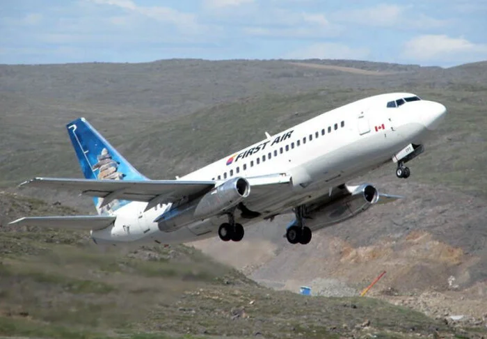
A First Air Boeing 737-200 thunders off Runway 17 at Iqaluit, the largest community in Nunavut and the centre of the Nunavut Government. First Air has operated big Boeings in the North for many years, having first used B727s (retired from service in 2009) and now with seven B737s (In All-cargo, Combi, and All-passenger configurations) and a cargo B767. The graphic on the tail of this B737 displays an Inukshuk, the stone landmark and navigation cairn found throughout the Inuit North. Photo from the First Air Bradley Children's Charity Calendar by Jason Miller

An Aerospatiale ATR-42 parked on the ramp at Iqaluit, the seat of Nunavut territorial government formerly known as Frobisher Bay. With wet tarmac, this is definitely shot in the summer. The ATR-42 is one of the most successful short-haul regional airliners in history. The rugged landing gear, super-reliable Pratt and Whitney PW 120 turboprop engines and 42-52 passenger capacity of the type endear it to airlines around the world. This particular aircraft (C-GSRR) started its flying career with the US-based Trans World Express and then, after ten years, was operated by Danish airline, Muk Air. Before coming to First Air in 2004, it was operated by Danish Air Transport. Photo from the First Air Bradley Children's Charity Calendar by Corey Kreamer

Though today we know the service as First Air, the name of the operating company is still Bradley Air Services Limited, the legendary bush plane operation first started by Russ Bradley in 1946. Back in the day, Bradley flew classic bush aircraft such as the de Havilland Beaver, Otter and Douglas C-47 Skytrain. Times have indeed changed in the North. Where single engine ski-planes opened up the routes without navigation aids, now massive cargo ships like this Boeing B767 (C-GKLY), seen taxiing at Iqaluit, can operate safely in marginal conditions like this rain-soaked and foggy day on Baffin Island. This big all-cargo heavy-lifter (C-GKLY) first came into airline service with American Airlines in 1983. Put into long-term storage in Roswell, New Mexico, it was acquired in 2007 by ABX Air and converted to the all-cargo configuration for their cargo fleet. It came to First Air in 2009. Photo from the First Air Bradley Children's Charity Calendar by Jason Miller

In the depth of winter, some locations in the High Arctic, which would not normally have an airport, can utilize the frozen sea ice for a temporary landing field. Frederick E. Hyde Fjord, a 150 kilometre deep cut from the Arctic Ocean into the northernmost peninsula of Greenland (sometimes called Peary Land) is inaccessible by air in the summer. Here, a First Air C-130 Hercules sits heavily on the frozen surface of Hyde Fjord – just about the farthest from civilization an airplane can get. Photo from the First Air Bradley Children's Charity Calendar by Burt Freitag
To fully understand the allure of flying in this extreme environment and why aircrews share a bond akin to a family, we think taking a look at flying in the Arctic through the photographic eye of one of its hard-working pilots would help explain how the extremes and wonders of the North serve to forge these bonds. We think one look at these images and you will begin to grasp the gravitational pull of the North.
A Demanding Environment for Centuries
For centuries, European and North American explorers were drawn to the rigours and challenges of the inhospitable Arctic environment. There were two powerful dreams that fuelled the imaginations and the expeditions that made the first tentative European forays into the land of the Inuit people – the discovery of the mythic Northwest Passage and the extreme physical and metaphysical challenge of reaching the North Pole, to stand on the metaphoric “Top of the World”. The physical demands and mortal risks involved in the journey to the Pole are so extreme, that it is often referred to as the “Horizontal Everest”.
While European and American adventurers risked and sometimes sacrificed their lives to achieve these two goals, all the while the Native peoples were not only surviving in this environment, but they were living harmonious, contented, and cultural existences in the world's most extreme environment - a frozen desert and mountainous landscape, devoid of ordinary vegetation, yet teeming with marine and ungulate life. Only today, with warming global temperatures, is the Northwest Passage safely navigable for short periods, but rarely still achieved. The reaching of the North Pole, a white man's ambition, is still as difficult on foot or sledge as it ever was, perhaps even more so given the shorter winters. But, with aviation, life has changed in the high Eastern Arctic of Canada forever.
The small, extremely isolated communities that hunker down on the flat landscapes of the interior or cling to the very edge of the continent, sheltered deep in the fjords, are now connected, reachable, and sustainable thanks to modern aircraft operators like Ottawa-based First Air. In operation since 1946, Bradley Air Services/First Air is one of the most experienced, most respected, best equipped and longest running airlines in the North. Operating a well-maintained fleet of passenger and cargo aircraft that run the gamut between short-haul airliners like the Aerospatiale ATR-42 and the massive Boeing B767 converted to cargo configuration.
Weather Challenges – met with professionalism and knowledge
Captain Douglas Fleck is an ATR-42 pilot with First Air. He is also one of Vintage Wings of Canada's cadre of pilots flying the venerable and diminutive de Havilland Tiger Moth. Douglas has learned a lot, in his young career, about flying in the challenging North, with its capricious weather and its navigational challenges. We asked him to put down some thoughts about flying in the High Arctic. Douglas tells us:
“Typically the weather isn't as good as you see in these pictures. Lots of the time it's downright awful. The worst is the late fall to December. Nothing is frozen yet, and you're well into the dark season. Basically, until everything freezes up, you're dealing with lots of fog, icing, and low ceilings.
Once things freeze up, it gets a lot better, with the best weather coming in March and April. Everything is still frozen and you are getting some prolonged sunlight back, although it's still super cold in March. Once the ice starts to break up, you're back into the crappy weather until late July. I suppose this is because the air has heated up a bit and it can accept a little more moisture, but you still get some serious fog. Early fall isn't too bad, with some decent days, but with winds off the ocean, as they are at this time, you can always expect fog.
One good thing about the dark season is, as you lose daylight, runway lights naturally become more effective. At some destinations, the bad weather might keep you from landing during daylight, but it becomes more achievable the more the daylight diminishes, because the effective visibility of the runway lights increases.
You can arrive on a perfectly fine VFR day in March, but because it gets super windy down at ground level, you run into a lot of blowing snow and difficult whiteout conditions. It's not at all uncommon to see the weather down to 1/8 mile visibility with the skies reported as clear. The whiteout condition can be as shallow as 10 ft, but if you can't see the runway, it will put a damper on your day.
When flying to remote destinations in mountainous locations, a crew must remain wary of mechanical turbulence. We learn to read the mountains and watch how the snow is coming off of them, or what kind of clouds are forming near them. These give good indications of what the wind is doing. It can be just five knots, but if it's from the wrong direction, you can get rocked around pretty good.
I've also learned to read the snow the same way a float plane pilot reads the water to see what the wind is doing. We don't always have reliable weather reports, or reliable weather reporters for that matter.”

Awaiting departure at Repulse Bay, Nunavut, First Officer Douglas Fleck (left), Flight Attendant Nadia Clyke and Captain Brad Mazurski beneath the Arctic Circle Arch monument. The monument and indeed the entire town of Repulse Bay sit on the Arctic Circle.

Despite having the benefit of a GPS and modern instruments, First Air pilots are required to be able navigate the old fashioned way. Here Captain Ryan Ducharme takes a sun shot through the windshield of a First Air ATR-42 to determine true direction, made easier with the sun in winter months being on or near the horizon. Photo by Douglas Fleck

Blake Reid, another of Vintage Wings of Canada's experienced biplane pilots, was also a First Air ATR-42 Captain. Today, Reid is training in Taiwan to fly as a First Officer on Boeing B747s with Eva Air. Here, he is on the approach onto runway 31 at Arctic Bay. Photo by Douglas Fleck

Flying in the Arctic means flying in darkness during the winter months, when the sun barely and briefly comes above the horizon. This means that, for much of the year, aircrews are flying in darkness on many VFR flights to some of the most challenging airfields in the world. Here, C-GHPW, one of two C-130 Hercules heavy lift transports in the service of First Air, takes on cargo at Cambridge Bay Airport. In civilian service, the legendary C-130 is known as the L-382G. One can read the history of this aircraft in the Canadian registration C-GHPW. With the last three letters being HPW, we can tell it was a Hercules that once belonged to the now-defunct Pacific Western Airlines. The isolated community of 1,500 souls at Cambridge Bay is on the south shore of Victoria Island in Nunavut. Photo by CambridgeBayWeather

Baffin Island is the fifth largest island on the planet at 500,000 square kilometres. It is situated adjacent to Greenland, the world's largest island. Bare and craggy in the summer, the northwest coast of Baffin Island takes on softer countenance in winter with a deep covering of snow. Despite the beauty and golden sunlight, being forced down in this unforgiving environment is not an option. Despite their age, the Hawker Siddeley HS-748 aircraft, recently taken out of First Air service, enjoyed long service in the North. This was because First Air maintenance employees took the safety of their passengers and aircrews very seriously. The trust that the First Air crews have in their equipment is borne by years of continuous operation and excellent maintenance of these older aircraft. Photo by Douglas Fleck

Heading northeast towards Pangnirtung at 14,000 feet on a clear day, Douglas Fleck, in the right seat of the Hawker Siddeley HS-748, photographs the islands that cling to the western shore of mighty Cumberland Sound, a massive bite into the flanks of Baffin Island from the Arctic Ocean. Just off the tip of the propeller hub is Nimigen Island, about 110 kilometres from “Pang”. The scene is framed by the starboard Rolls-Royce Dart turboprop. On days like this, when you can see for hundreds of kilometres, being a First Air pilot is one of the most rewarding jobs in the world. Photo by Douglas Fleck

Douglas Fleck, now a First Air ATR-42 Captain, took this photo (looking south down the famous Pangnirtung Pass) from the right seat as his aircraft transits eastbound across the valley at 14,000 feet. About 150 kilometres down this remote, yet well hiked pass, lies the town of Pangnirtung. In summer, First Air flies adventurous trekkers into Pangnirtung to take advantage of some of the world's most challenging, yet rewarding, hiking in nearby Auyuittuk National Park. Photo by Douglas Fleck

A view from the cockpit of a First Air ATR-42 as it begins its descent into Pangnirtung Fjord at 8,000 feet above the frigid Arctic Ocean waters and the unforgiving rocks. All approaches to “Pang” are Visual Flight Rules (VFR) at all times and crews must get below the overcast to begin their final letdown. Though it cannot be seen here, the Arctic community of Pangnirtung clings to the edge of the Fjord right where it disappears to the right in this shot. Photo by Douglas Fleck

To line up for Runway 24 at Pangnirtung, pilots flying eastbound are required to make a 180º turn within the throat of the fjord. At night, the landing lights of this ATR-42 would light up the granite cliffs of Mount Duval above “Pang” as the airliner rounds onto final. Photo by Douglas Fleck

Flying into “Pang” in the depth of an Arctic winter is more challenging than in summer, when sunlight reflecting from the water helps pilots discern the difference between land and Arctic Ocean. Luckily, the winter sun remains low on the horizon and offers up some seriously deep shadows. Photo by Douglas Fleck

Clinging to the southern edge of Pangnirtung Fjord, the village of Pangnirtung sits in the shadow of a 2,000-foot wall of granite known as Mount Duval. The single gravel Runway (17-24) of CYXP runs smack dab through the middle of the townsite, with homes a few hundred feet from the centreline. The consequences of losing spatial awareness in this environment are clearly evident. Photo by Douglas Fleck

A First Air ATR-42 approaches the remote community of Pangnirtung by flying down Pangnirtung Fjord, well below the surrounding mountain tops. One look out the windshield and it is clear that, should the conditions be marginal and at night, pilots have serious challenges ahead as they begin their Steep Slope Approach. Training, experience and familiarity with the terrain give the professional pilots of First Air what they need to get passengers safely to their families in “Pang” without navigational aids or an Instrument Landing System (ILS). Photo by Douglas Fleck

Scooching down the western face of Pangnirtung Fjord and heading nearly due south at about 5,000 feet, First Officer Douglas Fleck and his Captain settle down into the chasm to set up for the straight-in approach for Runway 24 at “Pang”. The point of land in the middle ground is known as Kunguk Pen and the Peninsula beyond that is Aulatsivik Point. The small town can just be made out at the edge of the western cliff face as the fjord turns west-southwest. Though this water is many kilometres deep into Baffin Island, it is indeed the Arctic Ocean. Photo by Douglas Fleck

First Officer Douglas Fleck snaps a photo of Pangnirtung's Runway 24 cutting through the middle of town. In the far distance we see where Pangnirtung Fjord opens to Cumberland Sound and the headland known as Nasauya Hill. The surrounding hills, mountains and granite bluffs make a night time approach in deteriorating weather a difficult task, undertaken only by experienced pilots such as those of First Air. Photo by Douglas Fleck

The venerable, rugged, reliable, simple, and long-serving Hawker Siddeley HS-748-2A on the ramp at Pangnirtung airport in early winter, sometime prior to 2011 when the last remaining First Air airframe was retired. For decades, First Air employed this true workhorse on short-haul routes throughout the Territories. Young pilots, hoping to rise over the years to the left seat of the company's larger aircraft, would start their careers as First Officers on this type. The “Hawker” is a medium-sized turboprop airliner originally designed by the British firm Avro in the late 1950s as a replacement for DC-3s, then in widespread service as feederliners. The Rolls-Royce Dart engines power large black and white striped propellers which, when turning at low RPM on the ramp, would create a visual pulsing effect that made them more visible. If you look at the propeller blades, you will see that two of them are black-white-black, while the other two are white-black-white. This offset striping results in the higher visibility pulsing effect. Photo by Douglas Fleck

In spring, the landscape around Runway 17 in Iqaluit begins to show the land beneath, but in winter, in whiteout conditions at ground level, having an ILS makes landing at this airfield an achievable goal. The ILS at Iqaluit is on Runway 35, from the opposite direction. Photo by Douglas Fleck
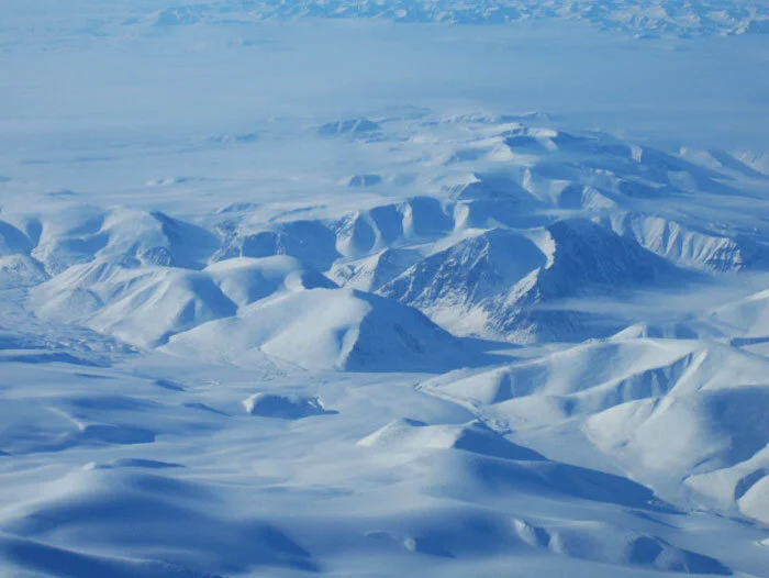
The landscape from 22,000 feet near Clyde River on Baffin Island looks beautiful and non-threatening, but beneath the soft mantle of winter snow lies one of the most rugged and remote mountain ranges on the planet. Photo by Douglas Fleck

About 40 kilometres from the village of Arctic Bay, an ATR-42 crew begins its descent into Adams Sound. Following the right side of the sound, the ATR-42 will soon settle into a final straight-in approach to Runway 31 at the Arctic Bay airport – a single gravel strip some eight kilometres from the townsite and around the last promontory in this photograph. Photo by Douglas Fleck

Running down the northern flank of Adams Sound, Fleck and crew prepare for a landing at Arctic Bay, Nunavut. The Arctic Bay area has been occupied for nearly 5,000 years by Inuit nomads migrating from the west. In 1872, a European whaling ship, the Arctic, captained by Willie Adams, passed through and gave the area its English name. Photo by Douglas Fleck

A shot from a First Air ATR-42 at 3,000 feet on approach to Runway 31 at Arctic Bay. The village of Arctic Bay lies at the very top of Baffin Island. It sits facing south on a deep bay near the mouth of Adams Sound, which slashes deep into Baffin Island from Admiralty Inlet, itself a gigantic fjord. Photo by Douglas Fleck

Douglas Fleck and the crew of a First Air ATR-42 fly 8,000 feet overhead Beechey Island in the Queen Elizabeth Archipelago. Beechey Island is separated from the southwest corner of Devon Island by Barrow Strait. Other features include Wellington Channel, Erebus Harbour, and Terror Bay. It is the site of several very significant events in the history of Arctic exploration. In 1845, the British explorer Sir John Franklin, commanding a new, but ill-fated, search for the Northwest Passage aboard HMS Erebus and HMS Terror, chose the protected harbour of Beechey Island for his first winter encampment. There are memorials to Franklin and other polar explorers and sailors on the island. Photo by Douglas Fleck

On the return journey, Fleck captures Beechey looking east at 15,000 feet. The first European to visit Beechey Island was Captain William Edward Parry, in 1819. Parry named the bleak, but sheltered, island for Frederick William Beechey, who was then serving as his lieutenant. Beechey Island sits attached to the southwest corner of Devon Island on the Northwest Passage by a thin thread of granite. Devon is the largest uninhabited island on the planet and Canada's sixth largest in area. Beechey Island is perhaps the most famous of the Arctic islands. In 1903, paying respect to Franklin, Norwegian explorer Roald Amundsen stopped at the island at the beginning of his successful voyage in search for the Northwest Passage. In popular fiction, the explorers in Jules Verne's novel, Voyages et aventures du capitaine Hatteras, visit Beechey Island. In addition, Clive Cussler's 2008 novel, Arctic Drift, featured characters that would visit this island in the quest for Franklin's ships. Beechy is also mentioned in Dan Simmons' novel, Terror. Photo by Douglas Fleck

In summertime, Beechey can be tolerable to curious visitors, but imagine trying to shelter here in the winter of 1845 with 24 hours of darkness, howling gales, driving snow and temperatures falling to minus 65ºF and lower. It is a tribute to the determination of Franklin's expedition members that only these graves were found on the Island. Their winter campsite was not discovered until 1851 when British and American search vessels anchored nearby. They found a large stone cairn, along with the graves of three of Franklin's crew – Petty Officer John Torrington, Royal Marine Private William Braine, and Able Seaman John Hartnell – but no written record or indication of where Franklin planned to sail the next season. The three men did not die of exposure, though this certainly weakened their health. Autopsies determined that lung disease and lead poisoning were among the probable causes of death. The lead probably came from lead-soldered tins of provisions with which the Franklin expedition had been supplied the water distillation system used by the ships. Photo by Ansgar Walk

Flying at 10,000 feet along Barrow Strait en route perhaps to Resolute Bay, we see old ice “growlers” and “bergy bits” from the previous winter coming down from the north in late summer and collecting in the Northwest Passage between Devon Island and Somerset Island. Soon temperatures will plummet, new ice will form around the old ice and the Northwest Passage will become unnavigable once again. Barrow Strait is a shipping waterway in Northern Canada's territory of Nunavut. Forming part of the Parry Channel, the strait separates several large islands including Cornwallis Island and Devon Island to the north, from Prince of Wales Island, Somerset Island, and Prince Leopold Island to the south. Photo by Douglas Fleck

Also over Barrow Strait, Douglas Fleck shoots a large ice pan floating in the shipping lane, surrounded by growlers. Considering that this First Air ATR-42 is at 10,000 feet, this ice pan is enormous, covering a few square miles. Barrow Strait is a shipping waterway in Northern Canada's territory of Nunavut.

On approach to Rankin Inlet (CYRT) on the northwestern coast of Hudson Bay. First visited by Europeans in the early 1600s, the Inlet was named for Lt. John Rankin of the British Royal Navy, but a town was not incorporated here until the 1950s. In 1721, explorer Captain James Knight and his crew were marooned on Marble Island, about 32 kilometres from Rankin Inlet. Knight was exploring, searching for valuable minerals and the Northwest Passage. His two ships were wrecked in the shallows, and he and his crew of 50 were stranded on the island.
The town of Rankin Inlet was created to house workers for a nickel mine in the 1950s. During the Korean War, the price of nickel rose sharply, and the North Rankin Nickel Mine was opened. The mine operated from 1957 to 1962 when a combination of declining prices and depletion of the ore body forced closure of the mine. Today, the town serves as the gateway to Nunavut, and economic hub of the Kivallig region. Photo by Douglas Fleck

The view from First Officer's seat of an ATR-42 at 4,000 feet on final for Runway 31 at Rankin Inlet, Nunavut. Rankin Inlet is a relatively larger community, found on the northwest coast of Hudson Bay, below the Arctic Circle. In this more western area of Nunavut territory, the land becomes flatter and more like the tundra of the Western Arctic. The colour of the water makes this appear to be somewhere in the Caribbean Sea. This photo was taken in late spring, when the ice begins to sink and water flows over the ice. The refractive qualities of ice produce the rich turquoise colour. The dense sea ice, like glacial ice absorbs all light except blue and the crystalline structure of the ice beneath the snow, exposed by the water, scatters blue light. Photo by Douglas Fleck

Bylot Island lies fast to the northern flank of Baffin Island. Ranked as the 71st largest island in the world, Bylot is totally uninhabited – a testament to the extreme difficulties of living on a frozen island creased with glaciers and devoid of vegetation. The island is named for the early Arctic explorer Robert Bylot, who was the first European to sight it in 1616. The whaling captain William Adams (the namesake for Adams Sound) was the first to determine the island's insular nature in 1872. The ATR-42 from which this photo was taken was making an approach to the community of Pond Inlet (on Baffin Island) on a heading east to west along Eclipse Sound which separates Bylot from Baffin. Photo by Douglas Fleck

From the right seat of his ATR-42, First Officer Fleck shoots a photo of Kaparoqtalik Glacier on Bylot Island, just across Eclipse Sound from the remote community of Pond Inlet. The shrinking glaciers of Bylot Island have been a bellwether for the effects of global warming on the Arctic. Photo by Douglas Fleck

The previous shot by Douglas Fleck brought to mind a famous painting by Canadian Group of Seven artist Lawren Harris. In 2010, a painting of Bylot Island, Mount Thule and Kaparoqtalik Glacier titled "Bylot Island I" by Harris, was sold at auction for $2.8 million, one of the highest prices ever paid for a work by a Canadian artist. In the summer of 1930, Harris and another famous Group of Seven painter, A.Y. Jackson, were invited to accompany the Canadian government supply ship Beothic on its annual voyage to the Arctic. They embarked at Sydney, Nova Scotia on 1 August, with the ship laden with supplies for the northern communities. Their first stop was Greenland before heading west to Ellesmere Island. I highly recommend you look at other paintings by Harris from his trip to the Arctic and in particular Bylot Island. (Type in Lawren Harris and Bylot in the Google search window).

Perhaps there is no more geologically interesting island in the High Arctic than the bizarre Prince Leopold Island which lies to the west of Resolute in the Qikiqtaaluk Region of Nunavut, Canada. It is located in Lancaster Sound at the junction of Prince Regent Inlet and Barrow Strait and is located just off the northeastern tip of Somerset Island. Prince Leopold is known as the 'Island of Freedom,' the vertical cliffs of Prince Leopold Island rise about 250 meters. The island was first sighted in 1819 by European explorer William Parry, and named in honour of His Royal Highness Prince Leopold Saxe Coburg, a German prince and cousin to Prince Albert, Queen Victoria's husband. Photo by Douglas Fleck

A summertime shot of Prince Leopold Island reveals one of the most geologically interesting, yet bleak, spots on the planet. The entire 14 kilometre by 8 kilometre island rises vertically out of Lancaster Sound with sheer cliffs of 1,000 feet on all sides. The island is a massive bird sanctuary and is noted for its extraordinary bird cliffs that house Thick-billed Murres, Northern Fulmars, and Black-legged Kittiwakes, who care for their young chicks on nests glued to the rocks with guano. The colony is estimated at a quarter of a million birds. Other species known to breed on the island include Atlantic Brant, Common Raven, Common Eider, Parasitic Jaeger, Glaucous Gull, and Snow Bunting. The seabirds generally occupy the site from early May to the end of August. The entire island is included within the Prince Leopold Island Migratory Bird Sanctuary (Federal Crown Land). It encompasses 311 square kilometres, which includes a 5 kilometre marine buffer around the island. An ungraded landing field is marked with sandbags on the flat surface at the southern end. The threshold of the “runway” begins at the edge of the cliff face, making landing short very problematic. Here is an amazing video of a landing by a Kenn Borek Twin Otter aircraft on Prince Leopold that shows us the challenges of the island field. Photo by TimothyK at Panoramio

The remote village of Qikiqtarjuaq (meaning “Big Island” in Inuktitut), lies on the northeastern flank of Baffin Island on Davis Strait, the massive run of Arctic water that separates Baffin Island from Greenland. At about 2,000 feet, heading south, and six miles from touchdown, First Officer Fleck photographs a breathtaking winter environment. Davis Strait is several hundred kilometres wide at this point and frozen solid, with late autumn icebergs caught in the ice for the winter. Qikiqtarjuaq bills itself as the Iceberg Capital of the World, with the headland near the town capturing many bergs as they slide down Davis Strait from Greenland. Photo by Douglas Fleck

The town of Qikiqtarjuaq (formerly Broughton Island) appears as the dark smudge to the right in this photo taken from the right seat of a First Air ATR-42 on short final over Davis Strait inbound for “Qik”. Winter days are normally very short and the area lies in total darkness for many weeks in the winter. This photo was taken during the best flying season in the High Arctic – March and April, when everything is still frozen hard and the low angled sun of a slightly longer day provides excellent visibility. Photo by Douglas Fleck

About one mile from touchdown at “Qik”, we see random tracks from locals enjoying a rip in their snowmobiles. Photo by Douglas Fleck

Seconds from touchdown, the ATR-42 flies past the new Qikiqtarjuaq Airport Terminal building and another unserviceable First Air ATR-42 awaiting rescue. The flight in, with Fleck in the right seat, was a rescue mission for the stranded crew. Qikiqtarjuaq is a relatively popular stop for pilots who fly smaller aircraft to and from Europe. The airport has a 3,800 foot by 100 foot gravel runway that is well compacted, well cared for, cleared of snow daily, and well lit. Photo by Douglas Fleck