
BARRENS AIRFIELD — Building a Flying Outpost

This story details my adventure at Hopes Advance Bay, a tidal bay on the west side of Ungava Bay in the extreme northern province of Québec, Canada during July–October 1956. It was merely a spot on aviators’ and mariners’ charts back in 1956. Today, the settlement is called Aupaluk.
To support their exploration of potential iron ore deposits in the region, the International Iron Ore Company (IIOC) required a runway. Ultimately, if large commercially viable deposits of iron ore were discovered and mined, they would create a town, construct a pelletizer and establish a deep water port from which to ship iron ore worldwide.
IIOC engaged the Tower Company Ltd. of Montréal to find a suitable runway location at Hopes Advance Bay. To that end, the Tower Company shipped construction equipment, two prefabricated buildings, food, fuel and supplies from Montréal to Ungava Bay. Those supplies were off-loaded above high water mark at Hopes Advance Bay and stored through the 1955–56 winter for use the following spring and summer. During the summer of 1956, a crew from Montréal would fly in to erect the buildings and construct the runway.
In early June 1956, I returned for my third summer with the Tower Company and learned of my assignment: to build the runway at Hopes Advance Bay. Not a bad deal for an engineering student just turned twenty-one.
In the office, I carefully reviewed the inventory of supplies and equipment off-loaded the previous summer at Hopes Advance Bay. Once there the only feasible way to receive additional supplies before completing the runway would be by seaplane. Iffy at best, since Hopes Advance Bay’s thirty foot tide is one of the highest in the world. Landing a float plane on a nearby lake and then hauling deliveries overland across the tundra on a skid pulled by a bulldozer was possible but impractical.
If we didn’t complete the runway during the summer and early fall, the thawed surface layer of frozen ground (the “active layer”) would refreeze and earth-moving would be impossible. We wouldn’t be able to fly out from the incomplete runway and would be marooned until the nearby lakes froze sufficiently to enable a ski plane to land on the ice to lift us out. Not a happy prospect.

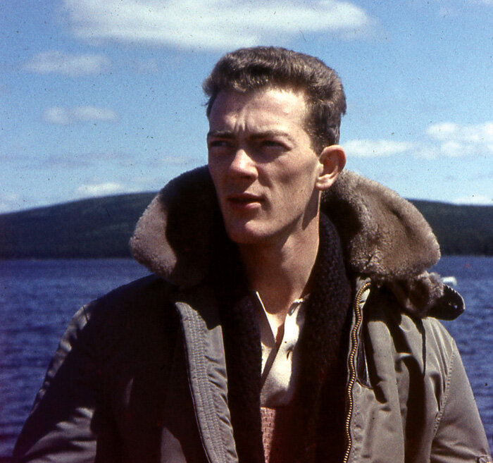
Young and jaunty Kelly Bridge in 1956, an engineering student with a remarkably important summer job—to build an airstrip in the remotest part of Québec. Photo: Kelly Bridge
Summers are short in the sub-Arctic but summer days are long. So, in order to complete the runway before winter returned, we worked long hours. Very long hours. This meant selecting an experienced and multi-skilled crew.
Interestingly, I only required a crew of three aside from myself. My cook was also a carpenter. The carpenter and I doubled as electricians. My bulldozer operator, a jack of all trades, knew how to erect the two 20’ by 40’ panelized buildings. As ringmaster, I could drive the dozer, supervise the crew erecting the buildings, set up the generator and wire the buildings.
Once my crew was carefully selected, thoroughly briefed and understood the scope of work, we headed north.
On Nordair we flew 900 miles northeast from Montréal to Fort Chimo (now Kuujjuak). We planned to stay overnight in Fort Chimo and take a float plane the next day 95 miles northwest to Hopes Advance Bay. The flight plan coincided with high tide so we could land safely in the bay, taxi to shore near our equipment cache, off-load our gear and allow the plane to turn and take off at high water. Alas, this wasn’t to be.

Kelly arrived at Fort Chimo on a Nordair DC-3. Later, when the runway was finished at Hopes Advance Bay, he would be picked up by another DC-3, that one painted in the markings of Mont Laurier Aviation. Nordair was created by the merger of Mont Laurier and Boreal Airways, so most likely the one that would pick him up had simply not yet been painted as a Nordair aircraft. Photo: Mel Lawrence at airliners.net
Related Stories
Click on image


Takeoff from the Koksoak River at Fort Chimo was uneventful but high winds and rough seas prevented us from landing on Hopes Advance Bay. However, we did spot our supplies on a beach at the southeast side of the bay.
The pilot circled the area so I could search for a suitable runway site close to the shore. One long, roughly northeast-southwest esker looked promising. An esker is a long winding ridge of stratified sand and gravel, examples of which occur in glaciated and formerly glaciated regions of Europe and North America. Eskers are frequently several kilometres long and, because of their peculiar uniform shape, are somewhat like railway embankments—the big ones are perfect for airfields.
Finally, the pilot selected a nameless lake a few miles from our supplies and we landed. We waved goodbye to the pilot and set about erecting tents and setting up camp. The weather was windy and overcast with occasional driving rain. Not a promising start.
Once warm food dispelled our dampened spirits, we formulated an action plan. We bedded down in twilight and awoke in twilight because of the continuous daylight at this latitude in early July.
After breakfast we broke camp and set out to locate and check out the supplies on the beach. Also, I examined the esker spotted earlier as a possible runway site.
We moved down to the beach and found all our equipment high and dry well above high tide. My operator/mechanic checked out the bulldozer, fuel, tools, diesel generator and the sheep’s foot rollers. There were several large timbers and the necessary hardware and wire cable to build a skid to haul material to our building site. Later, we used the same skid to drag the runway smooth.

Sitting well above high tide and the boulder strewn tidal shore we found the cache of food, fuel, equipment and shelter off-loaded the previous summer. The “sheep’s foot rollers” can be seen lower right. Photo: Kelly Bridge
The cook inventoried the stockpiled food… mostly dried fruit and vegetables and canned meat. He checked out the oil fired stove and cooking supplies.
The carpenter and I inventoried the two prefab buildings and associated construction material necessary to construct an outhouse for us and a shed for the diesel generator.
I determined that the esker we’d seen from the air was ideal for a runway. It was long enough and oriented close to the direction of prevailing winds. Though boulder strewn, it appeared reasonably level. So, all we needed to do was push the boulders aside, level the gravel to make a strip 100 feet wide and thirty-five hundred feet long with an adjacent parking apron and that would be that. Piece of cake? Not quite.
Near the proposed parking apron, we established a camp site where I decided to locate the buildings, the outhouse and the generator shed. It took another day to get the bulldozer running and to construct the skid. Meanwhile, I staked out the runway centre line.

The glacial esker from which a runway was carved. An esker is a long, narrow, steep-sided ridge of coarse sand, gravel and boulders deposited by a stream flowing in or under a melting sheet of glacial ice. Eskers range in height from 10 to more than 660 ft and in length from less than 300 ft to more than 300 miles long. Photo: Kelly Bridge
Once the bulldozer was operational, I ordered the operator to clear a strip fifty feet wide and a thousand feet long. With that complete, I knew a bush plane on wheels or skis could land with supplies or evacuate anyone who was sick or injured. Mostly, if the weather closed in before finishing the entire runway we wouldn’t be marooned, waiting for the nearby lakes to freeze over.

An in-progress shot showing the 100 foot wide and soon to be 3,500 foot long runway. Photo: Kelly Bridge

Being the land of the midnight sun, there were plenty of daylight hours available to the four-man crew, and they took advantage of it. Here, the dozer muscles Barren land dirt around with the sun barely making it to the horizon before it starts back up again. Photo: Kelly Bridge
With the bulldozer operational, the blade attached and the skid trailing behind we hauled material from the beach to the runway site. This took dozens of trips. Eventually everything reached a lay-down area near the runway site. We erected the buildings and created my fifty-foot-wide by one-thousand-foot-long provisional airstrip.
After it was complete, we spent several weeks lengthening and widening it to thirty-five hundred feet long and a hundred feet wide. Lastly, we created a 200’ x 200’ parking apron between the runway and our buildings.
One morning we awoke to loud and persistent honking sounds. With my first cup of coffee in hand, I opened the bunkhouse door and looked outside. Thick sea fog enveloped the whole site but through the mist I made out hundreds of Canada geese wandering about the runway. They were fogged in.
The cook said, “If you get a couple, we’ll enjoy cooked goose for a few days.”
With wrenches and rocks in hand, we crouch-walked slowly toward the runway and the honking geese. On a signal from me, we rose and threw rocks and wrenches into the tightly packed flock. Surprisingly, we managed to kill two or three. We enjoyed cooked goose, goose stew and goose hash for the better part of a week… a welcome change from our diet of dried and canned food.
Now, the runway was almost complete but one day, while dragging our skid back and forth along the surface to eliminate any slight elevation changes, we noticed what we thought was a small boulder just popping through the surface. Naturally, we decided to dig it up and push it to the runway’s edge. It wasn’t a boulder. It was huge.
It took several days to expose the entire boulder since the ground below the runway was permafrost and only thawed a few inches a day. Finally, I placed dynamite under the exposed boulder, back-filled soil and set off the charge to shatter the boulder. After pushing the pieces to the runway’s edge, we back-filled and compacted the large hole.

It took a heavy dozer to expose the “small” boulder—a remnant from the last glaciation period. Photo: Kelly Bridge

The only way to deal with the massive boulder was to dynamite it. Photo: Kelly Bridge

The boulder once some of Alfred Nobel’s magic formula had been applied. Photo: Kelly Bridge

Backfilling the hole left after dynamiting. Photo: Kelly Bridge

The finished runway. 100 feet wide and 3,500 feet long and remarkably smooth. Photo: Kelly Bridge

With winter coming in, the strip was finished and it was time to head south. We can see the buildings and the clear runway to the right under glowering fall skies. Photo: Kelly Bridge
I maintained a regular radio contact with Fort Chimo and provided progress reports to the Tower Company. Finally, I declared the runway complete. We were ready to go home or, in my case, return to university. I scheduled an evacuation flight.
We then decommissioned the site; drained pipes and traps, winterized the stove, space heaters, generator and bulldozer, and sealed wall and roof vents, roof stacks and windows to prevent snow infiltration.
In case anyone sought shelter during the winter (Inuit or crash survivors) we left emergency rations in one building: canned meat, dried fruit, the Primus stove, fuel, candles and matches, kerosene lanterns, flashlights, bedding, etc.
Ironically, after our rush to complete the runway and complete the site before winter, the weather closed in and our flight was postponed for several days.
While awaiting word of the aircraft’s scheduled arrival, we slept late, ate well, played cribbage, packed all our gear and readied ourselves for departure on short notice.
Finally, were heard the familiar sound of an aircraft overhead. A Mont Laurier Aviation DC-3 descended through the cloud base and circled the site. Next, it made a pass down one side of the runway at five hundred feet. Then it turned and made another slow pass down the other side.
Finally, it made a long turn into the wind, lowered wheels and flaps and lined up for landing. The pilot landed within a hundred feet of the approach threshold and stopped well before using all thirty-five hundred feet.
He taxied to the far end of the strip, turned around, taxied back to the apron and idled his engines.

Mont Laurier Aviation’s Douglas DC-3, with Chief Pilot Frank Henley alone in the cockpit, makes the first landing at Hopes Advance Bay runway. Photo: Kelly Bridge

Photo: Kelly Bridge

Mont Laurier’s chief pilot, Frank Henley, trundles the big DC-3 single-handedly up to the newly finished Hopes Advance Bay airfield ramp. Photo: Kelly Bridge

Fast forward 56 years from Henley’s single-handed landing at Hopes Advance Bay, and we find him on stage at Canada’s Aviation Hall of Fame Induction ceremony. The five 2013 inductees of Canada’s Aviation Hall of Fame stand together at the end of the night’s ceremonies. It was the Hall’s 40th anniversary induction ceremony. Henley stands second from left. Joseph Fernand “Frank” Henley established his career with the RCAF, and also bush flying. Henley held executive positions at Maritime Central Airways (MCA), Nordair and Hydro Québec, where he masterminded immense logistical effort to transport heavy equipment, supplies and personnel to the James Bay hydro project via air. In doing so, he pioneered the use of ice runways for the delivery of heavy loads by air. Henley was named to the Order of Canada in 2003. Photo and text: John Chalmers, Canada’s Aviation Hall of Fame

With the runway on the right, we look down the length of the field to the “ramp” and the buildings which housed the four-man crew during the summer. Photo: Kelly Bridge
Frank Henley, Mont Laurier’s Chief Pilot, was alone in the plane. He flew single handed to make this first cautious landing on my (it really was “my”) runway. We quickly loaded and secured our belongings and climbed aboard. After complimenting my crew and me on the smoothness of the runway, Captain Henley graciously asked if I’d like to sit in the co-pilot’s seat for the takeoff and flight to Fort Chimo. “But don’t touch anything,” he admonished.
He taxied slowly to the far end of the runway to get a feel for any surface ups or downs then turned and taxied to the near end to turn and take off.
With the plane lined up into the wind and all cockpit checks complete, Captain Henley advanced the throttles and began his takeoff roll. He used almost all the runway, not because he needed to (the plane was lightly loaded) but to get a feel for the surface.
Once airborne, he kindly made a long, slow circle so we could view the strip, the buildings and Hopes Advance Bay. I can still hear Captain Henley’s kind words as we climbed through the overcast toward Fort Chimo, “Nice job, kid.”
Back in Montréal, after completing my project reports, my crew and I were paid off and I returned to university in the States. That’s how I spent my summer vacation in 1956.
Afterword: The runway at Hopes Advance Bay still exists. Scheduled flights serving Aupaluk (Pop. 159) arrive and depart three times a week. The on-again off-again iron ore mine is a victim of worldwide demand and development is uneconomical at present. The mega mine and deep water port never came to pass. The tiny community was designed and is administered by Inuit who sustain themselves by fishing and hunting. Life there is much the same as it was fifty years ago.
Kelly Bridge spent a summer unlike most of his engineering classmates—building an airfield in Canada’s remotest region, one that remains today, nearly 60 years later. Photo: Kelly Bridge

By building the rugged Barren land airstrip, Kelly’s crew created a new community called Aupaluk, clinging precariously to the edge of Hopes Advance Bay and Kelly Bridge’s airstrip. Photo: Michael B. Kalinowski

An Air Inuit Dash 8 awaits passengers and cargo at the Aupaluk airport. Photo: Oceanic Iron Ore Co.

Accommodations at Hopes Advance bay are decidedly better than in the summer of 1956, but just as bleak. Photo: Nunavut Tourism

The airport terminal building at Aupaluk today. The letters beneath are the Inuktitut syllabic alphabet and language.

Hopes Advance Bay lies on the west coast of the massive Ungava Bay in Northern Québec. Image: Google maps

Zooming in much closer. Ungava is a large bay in northeastern Canada separating Nunavik (far northern Québec) from Baffin Island. The bay is roughly oval-shaped, about 260 km (160 mi) at its widest point and about 320 km (200 mi) in length; it has an area of approximately 50,000 km2 (19,000 sq mi). It is generally fairly shallow, under 150 m (490 ft), though at its border with the Atlantic Ocean depths of almost 300 m (980 ft) are reached. Image: Google maps

Hopes Advance Bay, 970 miles north of the city of Montréal. Kelly explains: “We arrived by float plane at the nameless lake ten miles west and walked east to find our cache.” Image: Google maps

We can now begin to see the runway that Kelly Bridge and his team built in 1956. Image: Google maps

As close as we can get. In this view the runway runs roughly north-south. It is still there fifty years later. The roads to the north and east came as the settlement grew at Aupaluk. Image: Google maps